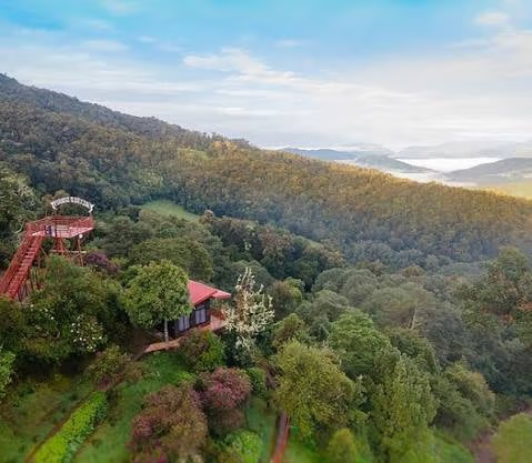
On a territory barely larger than Switzerland, Costa Rica brings together volcanoes, cloud forests, tropical plains, beaches on two oceans and mountain valleys. Each region has its own climate, wildlife and rhythm. Here are the 29 regions we love to share, grouped by major area, to help you compose your tailor-made trip.
In the heart of the Central Valley, at about 1,150 meters above sea level, the capital gathers the National Theater, the Pre-Columbian Gold and Jade museums, and the Mercado Central, where the smell of coffee lingers. One day is enough, at the start or end of the trip, to grasp the country’s urban soul.
The country’s capital until 1823, Cartago is home to the Basilica of Our Lady of the Angels, a national pilgrimage site, and the ruins of Santiago Apóstol. Nearby lie the Orosi Valley, its coffee plantations and the Lankester Botanical Garden, known for its orchids, and higher up Irazú Volcano.
On the Caribbean slope of the mountain range, Turrialba is the region of the Pacuare River, one of the most renowned rafting rivers, and of Guayabo National Monument, the country’s main archaeological site. A rural region, between coffee and sugar cane. See our rafting guide.
Reachable only by boat or small plane, this national park is a network of canals, lagoons and forests. Early-morning boat trips reveal caimans, monkeys, toucans and sloths; from July to October, green turtles come to nest on the beach. See our Tortuguero guide.
A village with a Caribbean rhythm, and a national park where a trail follows the beach between forest and reef. Monkeys, sloths, raccoons and iguanas can be seen up close; snorkeling is done with a guide. Coconut-milk cooking, such as rondón, is part of the journey.
A meeting place of Afro-Caribbean heritage, Bribri culture and travelers from all over the world. The beaches of Cocles, Playa Chiquita and Punta Uva, surfing, chocolate workshops and a relaxed atmosphere make it a popular stop.
At the end of the Caribbean road, the Gandoca-Manzanillo Wildlife Refuge protects mangroves, reefs and coastal forests. The waters, often clear in September and October, are ideal for snorkeling and kayaking; dolphins sometimes visit the coast.
In the foothills of the Talamanca range live the Bribri. Visits organized with the communities let you discover the traditional preparation of cacao, medicinal plants and their worldview, respecting their way of life.
A former banana region that has become a major ecotourism destination, with La Selva Biological Station. The Sarapiquí River can be rafted, and cacao and pineapple plantations open their doors. A rich stop for families and birdwatchers.
Near the Nicaraguan border, these wetlands are protected under the Ramsar Convention. In the dry season, spoonbills, anhingas, herons and jabirus gather here; boat trips also reveal caimans, monkeys and iguanas.
On the banks of the San Carlos River, a lowland forest still little visited, known for the great green macaw, an endangered parrot. Lodges organize sightings at sunrise. See our birdwatching guide.
Its 1,670-meter cone towers over La Fortuna. Dormant since 2010, it remains the center of a very complete region: hot springs, La Fortuna waterfall, hanging bridges, canyoning, rafting. See our La Fortuna guide.
Above 1,400 meters, a cloud forest covered with mosses, orchids and tree ferns. The quetzal is seen mainly from February to May. Founded partly by Quakers in the 1950s, the community has made conservation its priority. See our Monteverde guide.
The national park trail leads to a waterfall and to the spots where the river takes on its turquoise color, caused by the meeting of two streams with different mineral compositions. A half-day forest walk, often muddy.
In Guanacaste, fumaroles, bubbling mud pots, waterfalls and dry forest make up a more mineral landscape than that of the rainforests. Horseback riding, zip-lining and mud baths complete the visit.
A crescent-shaped bay, protected by a reef, with often calm waters: a good choice for family swimming and learning to surf. The village has kept a simple atmosphere.
A few kilometers from Sámara, a long beach of light sand lined with palm trees, with no buildings on the seafront. A quiet place for a beach day.
On the Gulf of Nicoya side, Paquera is the arrival port of the ferry from Puntarenas. Nearby, the Curú reserve is home to monkeys, deer and birds, and serves as a starting point for the islands of the gulf.
In the Gulf of Nicoya, an island of light sand and coconut palms, reached by boat on a day trip to swim, snorkel and have lunch on the beach.
From the bridge over the Tárcoles River, you can watch large American crocodiles. The neighboring Carara National Park, between dry and humid forest, is a good site for the scarlet macaw. A stop on the road to the Pacific.
A small national park where the forest comes down to the beaches: sloths, capuchin monkeys, squirrel monkeys and iguanas are seen along easy trails. The park is closed on Tuesdays. See our Manuel Antonio guide.
A surf village with a laid-back atmosphere, beaches that are still wild and, in the hills, the Nauyaca waterfalls, reached on foot or by four-wheel-drive vehicle.
The park takes its name from the whale-tail-shaped sandbar that appears at low tide. Humpback whales are present mainly from July to October, and in smaller numbers from December to March. See our whale watching guide.
On the edge of the Térraba-Sierpe mangrove, one of the largest in the country, this village is the departure point for boats to Drake. In the region, the pre-Columbian stone spheres of the Diquís are a UNESCO World Heritage Site.
You arrive by boat from Sierpe, along the river and then the coast, and the hotel welcomes you on the beach. Beaches, coastal trails and isolated lodges make it a base for Corcovado and Caño Island. See our Osa Peninsula guide.
Often described as one of the most biodiverse places on the planet, this national park is home to tapirs, anteaters, the country’s four monkey species and, more elusive, jaguars and pumas. It can only be visited with a certified guide.
A biological reserve off Drake, renowned for snorkeling and diving: turtles, rays, reef sharks and schools of fish. Landing on the island is regulated.
In the southern mountains, San Vito was founded by Italian immigrants in the 1950s. The Wilson Botanical Garden, run by the Organization for Tropical Studies, presents a major collection of tropical plants.
In a valley of the Talamanca range, above 2,000 meters, moss-covered oak forests shelter the quetzal, seen mainly from February to May. Trails, a trout river and cool mornings offer a change from the tropical coasts.
Arenal Volcano, Monteverde, Manuel Antonio and Tortuguero make a good base, with volcanoes, cloud forest, beaches and canals. See our two-week itinerary.
Two weeks for four or five regions; three weeks to add more remote regions such as the Osa Peninsula or Caño Negro.
Yes, it has been our work since 2014. Let’s talk about your project.
Learn more
Let’s talk about your trip
Your dates, your wishes, the pace that suits you: a travel consultant based in Costa Rica will suggest a tailor-made itinerary within 48 business hours.


